


| Burial Sites in Brentwood, New Hampshire |
|---|
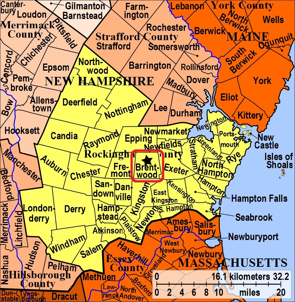
| To see a map of all sites click here. |
| ------ Bean, See: Sanborn/Bean, B16-003 |
| B16-005 Bean, South Road, USGS Kingston Quadrangle, E33105, N475851, Zone 19 (42° 57' 45"N, 71° 4' 17"W), Source: Lawrence Lyford 1993 MAP |
| B16-002 Brentwood Cemetery/New Cemetery, Route 111A (Middle Rd.), USGS Kingston Quadrangle, E33300, N476139, Zone 19 (42° 59' 20"N, 71° 2' 54"W), Source: Lawrence Lyford 1993 MAP |
| ------ Brown, See: Thyng/Brown, B16-015 |
| B16-014 Cram, off North Road, USGS Epping Quadrangle, E33254, N476407, Zone 19 (43° 0' 46"N, 71° 3' 17"W), Source: Lawrence Lyford 1993 MAP |
| ------ Dudley, See: Osgood/Dudley/Gordon, B16-007 |
| B16-018 Dudley, Pickpocket Road, USGS Kingston Quadrangle, E33596, N476116, Zone 19 (42° 59' 14"N, 71° 0' 43"W), Note: There is a Town Trust Fund for care. Source: Lawrence Lyford 1993 MAP |
| B16-020 Dudley/Kimball/Leavitt, Pickpocket Road, USGS Kingston Quadrangle, E33603, N476054, Zone 19 (42° 58' 54"N, 71° 0' 40"W), Source: Lawrence Lyford 1993 MAP |
| ------ Gordon, See: Osgood/Dudley/Gordon, B16-007 |
| B16-024 Gordon, Old Gordon Road, USGS Kingston Quadrangle, E33265, N476008, Zone 19 (42° 58' 37"N, 71° 3' 8"W), Source: Lawrence Lyford 1993 MAP |
| B16-021 Hanson, Deer Hill Road, USGS Epping Quadrangle, E33459, N476339, Zone 19 (43° 0' 26"N, 71° 1' 46"W), Source: Lawrence Lyford 1993 MAP |
| ------ Kimball, See: Swasey/Kimball/Rowell/Thyng, B16-019 |
| ------ Kimball, See: Dudley/Kimball/Leavitt, B16-020 |
| ------ Kimball, See: Swain/Kimball/Morse, B16-023 |
| ------ Leavitt, See: Dudley/Kimball/Leavitt, B16-020 |
| B16-008 Lyford, South Road, USGS Kingston Quadrangle, E33448, N475833, Zone 19 (42° 57' 42"N, 71° 1' 46"W), Source: Lawrence Lyford 1993 MAP |
| ------ Maplewood, See: Woods Corner/Maplewood/West Brentwood, B16-011 |
| ------ Morse, See: Swain/Kimball/Morse, B16-023 |
| ------ New Cemetery, See: Brentwood Cemetery/New Cemetery, B16-002 |
| B16-004 No Name, Route 111A (Middle Road) west of Pine Road, USGS Exeter Quadrangle, E33562, N476192, Zone 19 (42° 59' 39"N, 71° 0' 59"W), Note: This site has no name and no markers. Source: Lawrence Lyford 1993 MAP |
| ------ Old Town Cemetery, See: Veasey/Old Town Cemetery, B16-001 |
| B16-007 Osgood/Dudley/Gordon, South Road, USGS Kingston Quadrangle, E33230, N475832, Zone 19 (42° 57' 40"N, 71° 3' 22"W), Source: Lawrence Lyford 1993 MAP |
| B16-006 Quaker, South Road, USGS Kingston Quadrangle, E33237, N475838, Zone 19 (42° 57' 42"N, 71° 3' 19"W), Source: Lawrence Lyford 1993 MAP |
| B16-013 Rockingham County Home/Town Farm Cemetery, South Road, USGS Epping Quadrangle, E33609, N475812, Zone 19 (42° 57' 36"N, 71° 0' 34"W), Source: Lawrence Lyford 1993 MAP |
| ------ Rowe, See: Taylor/Rowe, B16-012 |
| ------ Rowell, See: Swasey/Kimball/Rowell/Thyng, B16-019 |
| B16-017 Rowell/Swasey/Thyng, Rowell Road, USGS Kingston Quadrangle, E33452, N476043, Zone 19 (42° 58' 50"N, 71° 1' 46"W), Source: Lawrence Lyford 1993, updated: Webmaster 2020 MAP |
| B16-003 Sanborn/Bean, Route 111A, USGS Kingston Quadrangle, E33154, N476090, Zone 19 (42° 59' 3"N, 71° 3' 58"W), Source: Lawrence Lyford 1993 MAP |
| B16-016 Shepard, Route 125, USGS Epping Quadrangle, E33077, N476417, Zone 19 (43° 0' 48"N, 71° 4' 36"W), Source: Lawrence Lyford 1993 MAP |
| B16-025 Smith, Rtes. 101 & 27, USGS Epping Quadrangle, E33422, N476456, Zone 19 (43° 1' 3"N, 71° 2' 4"W), Source: Lawrence Lyford 1993 MAP |
| B16-010 Smith/Wight, South Road, USGS Kingston Quadrangle, E33609, N475812, Zone 19 (42° 57' 36"N, 71° 0' 34"W), Source: Lawrence Lyford 1993 MAP |
| B16-023 Swain/Kimball/Morse, North Road, USGS Epping Quadrangle, E33398, N476411, Zone 19 (43° 0' 49"N, 71° 2' 14"W), Source: Lawrence Lyford 1993 MAP |
| ------ Swasey, See: Rowell/Swasey/Thyng, B16-017 |
| B16-019 Swasey/Kimball/Rowell/Thyng, Pickpocket Road, USGS Kingston Quadrangle, E33651, N475975, Zone 19 (42° 58' 29"N, 71° 0' 18"W), Source: Lawrence Lyford 1993 MAP |
| B16-012 Taylor/Rowe, North Road, USGS Epping Quadrangle, E33306, N476381, Zone 19 (43° 0' 38"N, 71° 2' 54"W), Source: Lawrence Lyford 1993 MAP |
| ------ Thyng, See: Rowell/Swasey/Thyng, B16-017 |
| ------ Thyng, See: Swasey/Kimball/Rowell/Thyng, B16-019 |
| B16-015 Thyng/Brown, Route 101, USGS Epping Quadrangle, E33570, N476412, Zone 19 (43° 0' 50"N, 71° 0' 58"W), Source: Lawrence Lyford 1993 MAP |
| ------ Town Farm Cemetery, See: Rockingham County Home/Town Farm Cemetery, B16-013 |
| B16-022 Tuck, Route 125, USGS Epping Quadrangle, E33046, N476277, Zone 19 (43° 0' 2"N, 71° 4' 48"W), Source: Lawrence Lyford 1993 MAP |
| B16-001 Veasey/Old Town Cemetery, Route 111A (Middle Rd.), USGS Kingston Quadrangle, E33306, N476145, Zone 19 (42° 59' 22"N, 71° 2' 52"W), Source: Lawrence Lyford 1993 MAP |
| B16-009 Wadleigh, South Road (on the Kingston Town Line), USGS Kingston Quadrangle, E33552, N475799, Zone 19 (42° 57' 31.43"N, 71° 0' 59.46"W), (GPS: 42.9588166°N, 71.0160179°W), Also listed as K04-009 Stevens/Wadleigh in Kingston Source: Lawrence Lyford 1993 MAP |
| ------ West Brentwood, See: Woods Corner/Maplewood/West Brentwood, B16-011 |
| ------ Wight, See: Smith/Wight, B16-010 |
| B16-011 Woods Corner/Maplewood/West Brentwood, Route 107, USGS Kingston Quadrangle, E32992, N475863, Zone 19 (42° 57' 47.74"N, 71° 5' 7.16"W), (GPS: 42.9633471°N, 71.0848254°W), Note: Names include: Ladd, Hanson & Fellows. Source: Lawrence Lyford 1993 MAP |
Listings Copyright © 1998-2024 New Hampshire Old Graveyard Association.
All rights reserved.
Send mail to webmaster@nhoga.org with questions or comments about this web site.