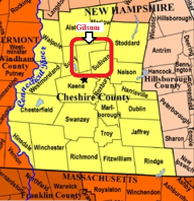


| Burial Sites in Gilsum, New Hampshire |
|---|
| Note: The sites with "red background" do not look correct on the Google maps corresponding to the lat/long coordinates for that cemetery. The problem may be either incorrect lat/long or changed street names. Please send any corrections to NHOGA Webmaster with corrected lat/longs in degrees/minutes/seconds or degrees + fractional degrees to 6 places. |
| To see a map of all sites click here. |
| G03-002 Bond, Centennial Road, USGS Walpole Quadrangle, E72220, N476897, Zone 18 (43° 2' 34.26"N, 72° 16' 19.75"W), (GPS: 43.0429090°N, 72.2717200°W), According to the original Gilsum listing, Bond is a separate cemetery, adjacent to and north of Centennial Hill. The two locations have been combined on Find A Grave. Source: Town of Gilsum, updated: Find A Grave 2019 MAP |
| G03-003 Centennial Hill, Centennial Road, USGS Walpole Quadrangle, E72224, N476887, Zone 18 (43° 2' 30.98"N, 72° 16' 18.12"W), (GPS: 43.0419998°N, 72.2712021°W), According to the original Gilsum listing, Bond and Centennial Hill are adjacent but separate cemeteries. They have been combined on Find A Grave. Source: Town of Gilsum, updated: Find A Grave 2019 MAP |
| G03-004 East Cemetery, Nash Corner Road, USGS Stoddard Quadrangle, E72572, N477077, Zone 18 (43° 3' 28.81"N, 72° 13' 41.73"W), (GPS: 43.0580788°N, 72.2277679°W), Nash Corner Road is designated Old Stoddard Road on original Gilsum listing. Source: Town of Gilsum, updated: Find A Grave 2019 MAP |
| ------ Gunn, See: South Cemetery, G03-007 |
| G03-006 Lower Village Cem., off Route 10, USGS Walpole Quadrangle, E72221, N476888, Zone 18 (43° 2' 31"N, 72° 16' 19"W), Note: This cemetery is listed on the original Gilsum listing, but it is unclear whether this is a distinct cemetery or just an alternate name for Centennial Hill, G03-003. Source: Town of Gilsum MAP |
| ------ Nash's Corner, See: East Cemetery, G03-004 |
| G03-007 South Cemetery, Off the end of Gunn Road, (GPS: 43.0006320°N, 72.2861450°W), Very remote. Oldest burial site in Gilsum. Not on original Gilsum listing. Source: Find A Grave 2019 MAP |
| G03-001 Vessel Rock, New Road, USGS Walpole Quadrangle, E72164, N476701, Zone 18 (43° 1' 31.38"N, 72° 16' 47.27"W), (GPS: 43.0255000°N, 72.2793000°W), Source: Town of Gilsum, updated: Find A Grave 2019 MAP |
| G03-005 Village Cemetery, Near Alstead Hill Rd. and Cemetery Road, USGS Walpole Quadrangle, E72280, N476975, Zone 18 (43° 2' 58.89"N, 72° 15' 52.13"W), (GPS: 43.0497818°N, 72.2639999°W), Source: Town of Gilsum, updated: Find A Grave 2019 MAP |
| ------ Ware Cemetery, See: Village Cemetery, G03-005 |
Listings Copyright © 1998-2024 New Hampshire Old Graveyard Association.
All rights reserved.
Send mail to webmaster@nhoga.org with questions or comments about this web site.