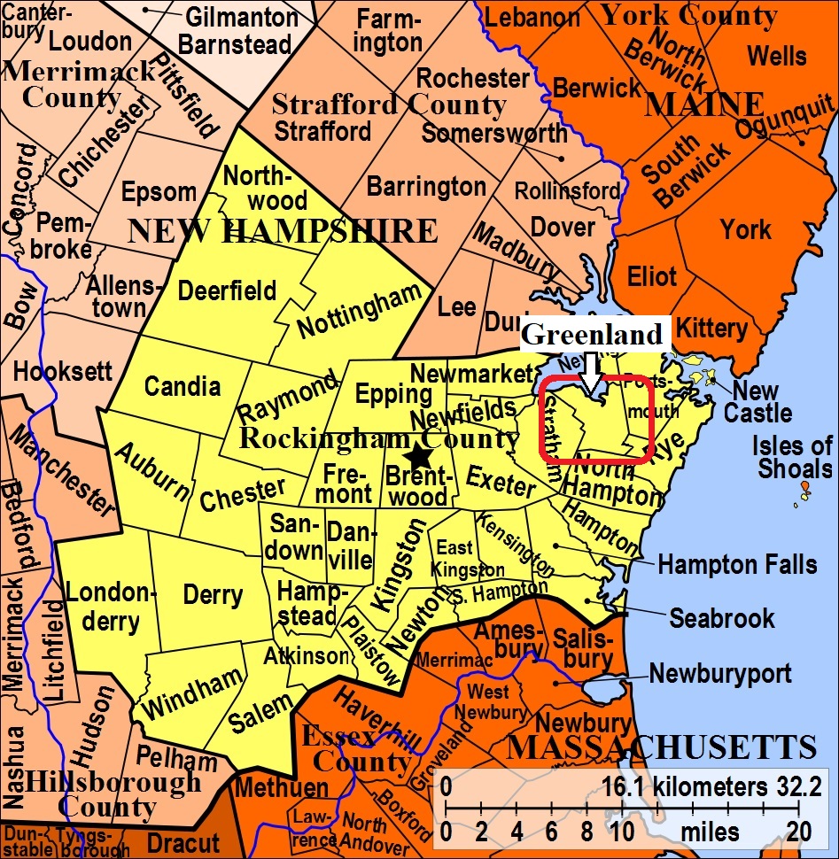


| Burial Sites in Greenland, New Hampshire |
|---|
| Note: The sites with "red background" do not look correct on the Google maps corresponding to the lat/long coordinates for that cemetery. The problem may be either incorrect lat/long or changed street names. Please send any corrections to NHOGA Webmaster with corrected lat/longs in degrees/minutes/seconds or degrees + fractional degrees to 6 places. |
| To see a map of all sites click here. |
| G10-001 Allen, eradicated, USGS Portsmouth Quadrangle, E34800, N476645, Zone 19 (43° 2' 15"N, 70° 51' 57"W), Master Map 200-A Source: Paul Hughes Sr. 1988 MAP |
| ------ Berry, See: Seavey/Berry, G10-027 |
| G10-002 Berry/Rand, Breakfast Hill Road, USGS Portsmouth Quadrangle, E35196, N476344, Zone 19 (43° 0' 40"N, 70° 48' 59"W), Master Map 45 Source: Paul Hughes Sr. 1988 MAP |
| G10-003 Brackett, Bayside Road, USGS Portsmouth Quadrangle, E34766, N476849, Zone 19 (43° 3' 21"N, 70° 52' 14"W), Master Map 222 Source: Paul Hughes Sr. 1988 MAP |
| G10-005 Brackett, off Bayside Road, USGS Portsmouth Quadrangle, E34782, N476855, Zone 19 (43° 3' 23"N, 70° 52' 7"W), Master Map 222-A Source: Paul Hughes Sr. 1988 MAP |
| G10-004 Brackett/Knight, Approximate former location, USGS Portsmouth Quadrangle, E34761, N476846, Zone 19 (43° 3' 20"N, 70° 52' 16"W), Removed to Prospect Hill, G10-025. Master Map 205 Source: Paul Hughes Sr. 1988 MAP |
| G10-007 Brackett/Pickering, Dearborn Road, USGS Newmarket Quadrangle, E34661, N476873, Zone 19 (43° 3' 28"N, 70° 53' 1"W), Master Map 216 Source: Paul Hughes Sr. 1988 MAP |
| G10-006 Brackett/Robinson, Bayside Road, USGS Newmarket Quadrangle, E34595, N476828, Zone 19 (43° 3' 13"N, 70° 53' 30"W), Master Map 217 Source: Paul Hughes Sr. 1988 MAP |
| G10-008 Cate, Dearborn Road, USGS Newmarket Quadrangle, E34695, N476769, Zone 19 (43° 2' 54"N, 70° 52' 45"W), Master Map 211-A Source: Paul Hughes Sr. 1988 MAP |
| ------ Coffin, See: Weeks/Coffin, G10-030 |
| G10-009 Davis, off Winnicut Road, USGS Portsmouth Quadrangle, E34869, N476456, Zone 19 (43° 1' 14"N, 70° 51' 25"W), Master Map 176 Source: Paul Hughes Sr. 1988 MAP |
| G10-010 Davis, Winnicut Road, USGS Portsmouth Quadrangle, E34889, N476489, Zone 19 (43° 1' 25"N, 70° 51' 16"W), Master Map 177 Source: Paul Hughes Sr. 1988 MAP |
| G10-011 Dearborn, eradicated, USGS Portsmouth Quadrangle, E35067, N476452, Zone 19 (43° 1' 14"N, 70° 49' 57"W), Master Map 29 Source: Paul Hughes Sr. 1988 MAP |
| ------ Early Settlers Burial Ground, See: First Town Cemetery/Early Settlers Burial Ground, G10-033 |
| G10-033 First Town Cemetery/Early Settlers Burial Ground, near Winnicut River, USGS Portsmouth Quadrangle, E34959, N476648, Zone 19 (43° 2' 17"N, 70° 50' 47"W), Master Map 243, For more information on this cemetery. Click here Source: Paul Hughes Sr. 1988 MAP |
| G10-012 Fox/Wood, eradicated, USGS Portsmouth Quadrangle, E34982, N476393, Zone 19 (43° 0' 55"N, 70° 50' 34"W), Master Map 19 Source: Paul Hughes Sr. 1988 MAP |
| G10-013 Goss, near Great Bay, USGS Portsmouth Quadrangle, E34800, N476865, Zone 19 (43° 3' 26"N, 70° 51' 59"W), Master Map 223 Source: Paul Hughes Sr. 1988 MAP |
| G10-014 Haines, eradicated, USGS Portsmouth Quadrangle, E34952, N476577, Zone 19 (43° 1' 54"N, 70° 50' 49"W), Master Map 168 Source: Paul Hughes Sr. 1988 MAP |
| G10-016 Hillside, Main Road (one of the large town owned cemeteries), USGS Portsmouth Quadrangle, E35030, N476627, Zone 19 (43° 2' 11"N, 70° 50' 15"W), Master Map 146 Source: Paul Hughes Sr. 1988 MAP |
| G10-017 Jack, Dearborn Road, USGS Newmarket Quadrangle, E34694, N476800, Zone 19 (43° 3' 4"N, 70° 52' 46"W), Master Map 214 Source: Paul Hughes Sr. 1988 MAP |
| ------ Knight, See: Brackett/Knight, G10-004 |
| G10-018 Lang/Whidden, off Downs Ave. USGS Portsmouth Quadrangle, E35048, N476474, Zone 19 (43° 1' 21"N, 70° 50' 6"W), Master Map 26 Source: Paul Hughes Sr. 1988 MAP |
| G10-019 Maloon, off Bayside Road, USGS Portsmouth Quadrangle, E34827, N476762, Zone 19 (43° 2' 53"N, 70° 51' 46"W), Source: Master Map 228 MAP |
| G10-020 March Tomb, off Newington, USGS Portsmouth Quadrangle, E35189, N476772, Zone 19 (43° 2' 59"N, 70° 49' 7"W), Master Map 111 Source: Paul Hughes Sr. 1988 MAP |
| G10-015 Marston, eradicated, USGS Portsmouth Quadrangle, E34972, N476382, Zone 19 (43° 0' 51"N, 70° 50' 39"W), Master Map 15 Source: Paul Hughes Sr. 1988 MAP |
| G10-021 Negro, off Bayside Road, USGS Newmarket Quadrangle, E34645, N476844, Zone 19 (43° 3' 18"N, 70° 53' 8"W), Master Map 217-A Source: Paul Hughes Sr. 1988 MAP |
| G10-022 Norton, off Post Road (Rte. 151), USGS Portsmouth Quadrangle, E34997, N476327, Zone 19 (43° 0' 33"N, 70° 50' 27"W), Master Map 11 Source: Paul Hughes Sr. 1988 MAP |
| G10-023 Norton/Randall, Post Road (Rte. 151), USGS Portsmouth Quadrangle, E34990, N476381, Zone 19 (43° 0' 51"N, 70° 50' 31"W), Master Map 17 Source: Paul Hughes Sr. 1988 MAP |
| ------ Parrott, See: Toscan/Parrott, G10-029 |
| G10-024 Pearson, eradicated, USGS Portsmouth Quadrangle, E35094, N476520, Zone 19 (43° 1' 36"N, 70° 49' 46"W), Master Map 62 Source: Paul Hughes Sr. 1988 MAP |
| ------ Pickering, See: Brackett/Pickering, G10-007 |
| G10-025 Prospect Hill, off Main Road (active town owned cemetery), USGS Portsmouth Quadrangle, E35044, N476593, Zone 19 (43° 1' 60"N, 70° 50' 9"W), Master Map 83 Source: Paul Hughes Sr. 1988 MAP |
| ------ Rand, See: Berry/Rand, G10-002 |
| ------ Randall, See: Norton/Randall, G10-023 |
| ------ Robinson, See: Brackett/Robinson, G10-006 |
| G10-026 Robinson, eradicated, USGS Portsmouth Quadrangle, E34816, N476598, Zone 19 (43° 1' 60"N, 70° 51' 50"W), Master Map 194 Source: Paul Hughes Sr. 1988 MAP |
| G10-027 Seavey/Berry, Breakfast Hill Road, USGS Portsmouth Quadrangle, E35218, N476324, Zone 19 (43° 0' 34"N, 70° 48' 50"W), Master Map 50 Source: Paul Hughes Sr. 1988 MAP |
| G10-028 Simpson, Winnicut Road, USGS Portsmouth Quadrangle, E34882, N476500, Zone 19 (43° 1' 28"N, 70° 51' 20"W), Master Map 178 Source: Paul Hughes Sr. 1988 MAP |
| G10-029 Toscan/Parrott, off Ann's Lane, USGS Portsmouth Quadrangle, E35125, N476717, Zone 19 (43° 2' 41"N, 70° 49' 34"W), Master Map 121 Source: Paul Hughes Sr. 1988 MAP |
| G10-031 Weeks, off Bayside Road, USGS Portsmouth Quadrangle, E34828, N476866, Zone 19 (43° 3' 27"N, 70° 51' 47"W), Master Map 226 Source: Paul Hughes Sr. 1988 MAP |
| G10-030 Weeks/Coffin, off Bayside Road, USGS Portsmouth Quadrangle, E34893, N476733, Zone 19 (43° 2' 44"N, 70° 51' 17"W), Master Map 233 Source: Paul Hughes Sr. 1988 MAP |
| ------ Whidden, See: Lang/Whidden, G10-018 |
| G10-032 Wiggin, off Haines Lane, USGS Portsmouth Quadrangle, E34944, N476504, Zone 19 (43° 1' 30"N, 70° 50' 52"W), Master Map 174 Source: Paul Hughes Sr. 1988 MAP |
| ------ Wood, See: Fox/Wood, G10-012 |
Listings Copyright © 1998-2024 New Hampshire Old Graveyard Association.
All rights reserved.
Send mail to webmaster@nhoga.org with questions or comments about this web site.