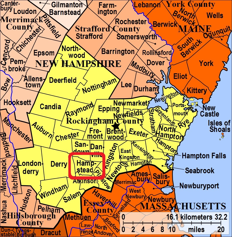


| Burial Sites in Hampstead, New Hampshire |
|---|
| Note: The sites with "red background" do not look correct on the Google maps corresponding to the lat/long coordinates for that cemetery. The problem may be either incorrect lat/long or changed street names. Please send any corrections to NHOGA Webmaster with corrected lat/longs in degrees/minutes/seconds or degrees + fractional degrees to 6 places. |
| To see a map of all sites click here. |
| H03-008 Cemetery (Family name for site is unknown), Route 121A, USGS Sandown Quadrangle, E32574, N474903, Zone 19 (42° 52' 33"N, 71° 8' 1"W), Source: GS map of Sandown MAP |
| H03-001 East Road Cemetery, East Road (on the Atkinson Border), USGS Haverhill Quadrangle, E32515, N474703, Zone 19 (42° 51' 28"N, 71° 8' 25"W), Source: Steve Harms, 1998 MAP |
| H03-002 Hadley, Emerson Ave. USGS Sandown Quadrangle, E32570, N474923, Zone 19 (42° 52' 40"N, 71° 8' 3"W), Source: Steve Harms, 1998 MAP |
| H03-003 Lakeview, Wash Pond Road, USGS Sandown Quadrangle, E32158, N475068, Zone 19 (42° 53' 23"N, 71° 11' 6"W), Source: Steve Harms, 1998 MAP |
| ------ Old Cemetery, See: Village Cemetery, H03-007 |
| H03-004 Pine Grove/West Hampstead Cemetery, off Chase Road (near the Sandown Boundary), USGS Sandown Quadrangle, E31949, N475306, Zone 19 (42° 54' 39"N, 71° 12' 41"W), Source: Steve Harms, 1998 MAP |
| H03-005 Pine Knoll, Route 111, USGS Sandown Quadrangle, E32550, N475081, Zone 19 (42° 53' 31"N, 71° 8' 13"W), Source: Steve Harms, 1998 MAP |
| H03-006 Soldiers' Cemetery, Hunt Road, USGS Kingston Quadrangle, E32766, N475095, Zone 19 (42° 53' 37"N, 71° 6' 38"W), Source: Steve Harms, 1998 MAP |
| H03-007 Village Cemetery, Route 121, USGS Sandown Quadrangle, E32168, N474909, Zone 19 (42° 52' 32"N, 71° 10' 60"W), Source: Steve Harms, 1998 MAP |
| ------ West Hampstead Cemetery, See: Pine Grove/West Hampstead Cemetery, H03-004 |
Listings Copyright © 1998-2024 New Hampshire Old Graveyard Association.
All rights reserved.
Send mail to webmaster@nhoga.org with questions or comments about this web site.