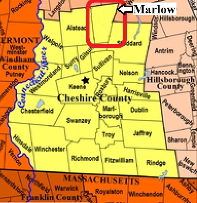


| Burial Sites in Marlow, New Hampshire |
|---|
| To see a map of all sites click here. |
| ------ Baker Corner, See: West End Cemetery, M05-001 |
| M05-004 Early Settlers Cemetery, Sargent Road, USGS Stoddard Quadrangle, E72606, N477861, Zone 18 (43° 7' 42.31"N, 72° 13' 15.23"W), (GPS: 43.1285040°N, 72.2204730°W), Source: Marlow Hist Soc/Find A Grave 2020 MAP |
| M05-003 Edson, South Road, Small family site, exact location private, (Coordinates needed) Source: Marlow Hist Soc/Find A Grave 2020 |
| ------ Jay Allen Cemetery, See: West End Cemetery, M05-001 |
| M05-002 Village Cemetery, Church Street, USGS Stoddard Quadrangle, E72748, N477744, Zone 18 (43° 7' 2.89"N, 72° 12' 14.19"W), (GPS: 43.1175250°N, 72.2035220°W), Source: NHHS 1975, updated: Marlow Hist Soc/Find A Grave 2020 MAP |
| M05-001 West End Cemetery, off Guston Pond Road, USGS Bellows Falls Quadrangle, E72346, N478105, Zone 18 (43° 9' 4.09"N, 72° 15' 6.63"W), (GPS: 43.1511917°N, 72.2513809°W), This is on Jay Allen Road off Guston Pond Road. Source: NHHS 1975, updated: Marlow Hist Soc/Find A Grave 2020 MAP |
| ------ West Yard, See: West End Cemetery, M05-001 |
Listings Copyright © 1998-2024 New Hampshire Old Graveyard Association.
All rights reserved.
Send mail to webmaster@nhoga.org with questions or comments about this web site.