


| Burial Sites in Seabrook, New Hampshire |
|---|
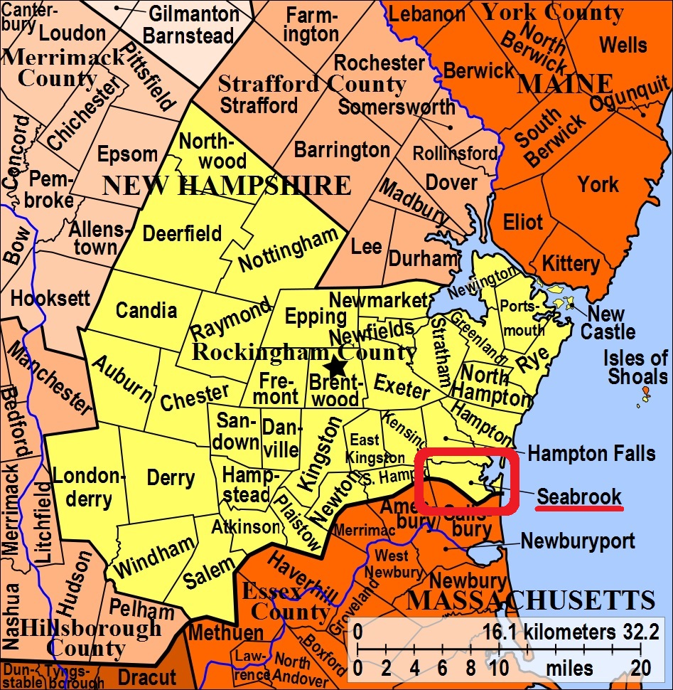
| To see a map of all sites click here. |
| ------ Brown Graveyard, See: Elmwood, S07-001 |
| S07-007 Chevy Chase, Off Provident Way, USGS Hampton Quadrangle, E34722, N475037, Zone 19 (42° 53' 33.30"N, 70° 52' 15.87"W), (GPS: 42.8926735°N, 70.8705710°W), Source: Laura Mitchell 2024 MAP |
| ------ Eaton, See: Oliver Eaton Burial Site, S07-010 |
| S07-001 Elmwood, Route 1, USGS Hampton Quadrangle, E34737, N475144, Zone 19 (42° 54' 8.08"N, 70° 52' 10.31"W), (GPS: 42.9023064°N, 70.8690619°W), Source: NHHS 1975, Updated: Find a Grave 2024 MAP |
| S07-002 Gove, Route 1, USGS Hampton Quadrangle, E34722, N475080, Zone 19 (42° 53' 47.24"N, 70° 52' 16.29"W), (GPS: 42.8965800°N, 70.8707100°W), Source: NHHS 1975, Updated: Find a Grave 2024 MAP |
| ------ Gove, See: Nancy Locke Gove Burial Site, S07-011 |
| S07-008 Gove Mausoleum, Off Fogg's Lane, USGS Hampton Quadrangle, E34666, N475116, Zone 19 (42° 53' 58.50"N, 70° 52' 41.32"W), (GPS: 42.8996342°N, 70.8776654°W), Note: This site is on private property and is not accessible without permission. Source: Laura Mitchell 2024 MAP |
| S07-006 Hillside Cemetery, Route 1, USGS Newburyport Quadrangle, E34728, N474832, Zone 19 (42° 52' 26.92"N, 70° 52' 11.22"W), (GPS: 42.8742600°N, 70.8693300°W), Note: This site is adjacent to the Methodist Cemetery. The two sites were previously combied under the name of Smithtown Cemetery. Source: NHHS 1975, Updated: Eric Small & Laura Mitchell 2024 MAP |
| S07-009 Johnson, Weare Road, USGS Hampton Quadrangle, E34474, N475118, Zone 19 (42° 53' 57.75"N, 70° 54' 5.96"W), (GPS: 42.8994886°N, 70.9011776°W), Source: Laura Mitchell 2024 MAP |
| ------ Line Church Cemetery, See: Elmwood, S07-001 |
| ------ Lower Smithtown, See: Methodist Cemetery, S07-004 |
| ------ Maple Grove Cemetery, See: Elmwood, S07-001 |
| S07-004 Methodist Cemetery, Route 1, USGS Newburyport Quadrangle, E34724, N474843, Zone 19 (42° 52' 30.46"N, 70° 52' 13.09"W), (GPS: 42.8751900°N, 70.8698400°W), Note: This site is adjacent to the Hillside Cemetery. The two sites were previously combied under the name of Smithtown Cemetery. Source: NHHS 1975, Updated: Eric Small & Laura Mitchell 2024 MAP |
| S07-011 Nancy Locke Gove Burial Site, Intersection of Routes 1 and 107, USGS Hampton Quadrangle, E34703, N475052, Zone 19 (42° 53' 38.03"N, 70° 52' 24.39"W), (GPS: 42.8939500°N, 70.8728998°W), Note: Single grave. Grave relocated to current location in early 2000s due to road construction. Source: Laura Mitchell 2024 MAP |
| S07-010 Oliver Eaton Burial Site, Off Walton Road behind American Legion Post, USGS Hampton Quadrangle, E34839, N474881, Zone 19 (42° 52' 43.60"N, 70° 51' 22.80"W), (GPS: 42.8788219°N, 70.8557775°W), Note: Single grave. Source: Laura Mitchell 2024 MAP |
| S07-003 Quaker Burying Ground, Route 1, USGS Hampton Quadrangle, E34734, N475142, Zone 19 (42° 54' 7.41"N, 70° 52' 11.61"W), (GPS: 42.9021480°N, 70.8693878°W), Note: This site has long since been incorporated into the municipal Elmwood Cemetery. The Society of Friends had their meeting house and adjacent burying ground at this site. A commemerative marker indicates the portion of Elmwood that was the original Quaker burying ground. Source: Laura Mitchell 2024 MAP |
| ------ Smithtown, See: Hillside Cemetery, S07-006. and Methodist Cemetery, S07-004 |
| ------ Upper Smithtown, See: Hillside Cemetery, S07-006 |
| S07-005 Wildwood, off So. Main St, USGS Newburyport East Quadrangle, E34876, N474734, Zone 19 (42° 51' 56.23"N, 70° 51' 5.07"W), (GPS: 42.8657087°N, 70.8509042°W), Source: NHHS 1975 MAP |
Listings Copyright © 1998-2024 New Hampshire Old Graveyard Association.
All rights reserved.
Send mail to webmaster@nhoga.org with questions or comments about this web site.