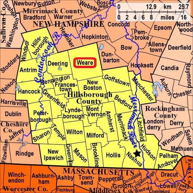


| Burial Sites in Weare, New Hampshire |
|---|
| Note: The sites with "red background" do not look correct on the Google maps corresponding to the lat/long coordinates for that cemetery. The problem may be either incorrect lat/long or changed street names. Please send any corrections to NHOGA Webmaster with corrected lat/longs in degrees/minutes/seconds or degrees + fractional degrees to 6 places. |
| To see a map of all sites click here. |
| W07-036 Bean, Not located, (Location unknown), The Bean site was said to be located on Burnt Hill. (Coordinates needed) Source: Unknown |
| W07-003 Burbank, Not located, (Location unknown), (Coordinates needed) Source: Unknown |
| W07-031 Buxton, Not located, (Location unknown), The David Buxton site was said to be located on the Old Francestown Road. (Coordinates needed) Source: Unknown |
| W07-012 Buxton/Philbrick Cemetery, Philbrick Road, USGS Weare Quadrangle, E27797, N476724, Zone 19 (43° 1' 38"N, 71° 43' 30"W), Source: Russ Battersby 1993 MAP |
| W07-011 Center Square, East Street, USGS Weare Quadrangle, E27865, N477490, Zone 19 (43° 5' 47"N, 71° 43' 11"W), Source: Russ Battersby 1993 MAP |
| W07-039 Chase, 30 Gould Road, USGS Weare Quadrangle, E28154, N476878, Zone 19 (43° 2' 32"N, 71° 40' 55"W), Source: Russ Battersby 1993 MAP |
| W07-018 Collins, 392 Reservoir Drive, USGS Deering Quadrangle, E27353, N477688, Zone 19 (43° 6' 45.85"N, 71° 47' 0.35"W), (GPS: 43.1128138°N, 71.7829500°W), Source: Russ Battersby 1993, Updated: Sue Fetzer 2016 MAP |
| W07-001 Corliss, Mountain Road, USGS Deering Quadrangle, E27512, N476820, Zone 19 (43° 2' 6"N, 71° 45' 37"W), Source: Russ Battersby 1993 MAP |
| W07-035 Cram, Not located, (Location unknown), The Cram site was said to be located on Cram Road. (Coordinates needed) Source: Unknown |
| ------ Currier, See: Wells/Currier, W07-029 |
| W07-021 Dow (Elijah), Dudley Brook Rd, USGS Deering Quadrangle, E27245, N477450, Zone 19 (43° 5' 28"N, 71° 47' 45"W), Source: Russ Battersby 1993 MAP |
| W07-023 Dow/Peaslee, Concord Stage Road, USGS Weare Quadrangle, E27661, N477652, Zone 19 (43° 6' 37"N, 71° 44' 44"W), Source: Russ Battersby 1993 MAP |
| W07-010 East Weare, Buzzell Hill Road, USGS Weare Quadrangle, E27857, N477510, Zone 19 (43° 5' 54"N, 71° 43' 15"W), Present location in Weare Center. Entire cemetery was relocated here from East Weare. Source: Russ Battersby 1993 MAP |
| W07-010X East Weare (previous location), East Weare Road in East Weare Village (location approximate), USGS Weare Quadrangle, E28293, N477635, Zone 19 (43° 6' 39"N, 71° 40' 4"W), Previous location in East Weare. Entire cemetery was relocated to Weare Center due to flood control project. Source: 1949 USGS map 2024 MAP |
| ------ Eaton, See: Sugar Hill, W07-006 |
| W07-037 Felch (Benjamin), On conservation land, (GPS: 43.1180000°N, 71.6947600°W), The Benjamin Felch Tomb was said to located on Lot 23, Range 6. Source: Unknown, GPS updated Find a Grave 2024 MAP |
| W07-025 Friends, New South, Thorndike Road, USGS Deering Quadrangle, E27528, N477333, Zone 19 (43° 4' 53"N, 71° 45' 38"W), Source: Russ Battersby 1993 MAP |
| W07-008 Friends, North, Quaker Street, USGS Weare Quadrangle, E27638, N477566, Zone 19 (43° 6' 9"N, 71° 44' 53"W), Source: Russ Battersby 1993 MAP |
| W07-007 Friends, Old South, Shady Hill Road, USGS Deering Quadrangle, E27538, N477310, Zone 19 (43° 4' 45"N, 71° 45' 33"W), Source: Russ Battersby 1993 MAP |
| W07-033 Gillett, Not located, (Location unknown), The John Gillett site was said to be located on the Concord Stage Road. (Coordinates needed) Source: Unknown |
| W07-014 Gove (Elijah), Mountain Road, USGS Weare Quadrangle, E27675, N476892, Zone 19 (43° 2' 32"N, 71° 44' 27"W), Source: Russ Battersby 1993 MAP |
| W07-038 Green (Ezra), Eben Paige Road, USGS Weare Quadrangle, (GPS: 43.0300170°N, 71.7790000°W), Source: Mike Zienkiewicz 2020 MAP |
| W07-016 Hadley, Mt. Dearborn Road, USGS Weare Quadrangle, E27825, N476767, Zone 19 (43° 1' 53"N, 71° 43' 19"W), Source: Russ Battersby 1993 MAP |
| W07-004 Hillside, Deering Center Rd. (Rte. 149), USGS Weare Quadrangle, E27822, N476991, Zone 19 (43° 3' 5"N, 71° 43' 23"W), Also known as South Weare Cemetery Source: Russ Battersby 1993 MAP |
| W07-022 Johnson, Relocated (Previous location unknown), The Tristram Johnson Cemetery was relocated to Weare Center. It had been on Bart Clough Road. (Coordinates needed) Source: Russ Battersby 1993 |
| W07-030 Johnson, 24 Buzzell Hill Road, (GPS: 43.0980010°N, 71.7208550°W), Source: Sue Fetzer 2016 MAP |
| W07-027 Lock (Luther), Oliver Road, USGS Deering Quadrangle, E27452, N477072, Zone 19 (43° 3' 27"N, 71° 46' 8"W), Source: Russ Battersby 1993 MAP |
| W07-034 Mudgett, Not located, (Location unknown), The Mudgett site was said to be located on Mt. Dearborn. (Coordinates needed) Source: Unknown |
| W07-009 Muzzey, Upper Craney Hill Rd, (GPS: 43.1183400°N, 71.7871600°W), Probably on private land. Source: Unknown, GPS updated: Find a Grave 2024 MAP |
| W07-005 Oil Mill Cemetery, River Road, USGS Weare Quadrangle, E28408, N477005, Zone 19 (43° 3' 16"N, 71° 39' 5"W), Source: Russ Battersby 1993 MAP See: Find a Grave |
| W07-026 Osborne, Not located, (Location unknown), The Samuel Osborne site is said to be located on Maplewood Road. (Coordinates needed) Source: Unknown |
| W07-015 Perkins, Mt. Dearborn Road, USGS Weare Quadrangle, E27671, N477073, Zone 19 (43° 3' 30"N, 71° 44' 31"W), Source: Russ Battersby 1993 MAP |
| ------ Philbrick, See: Buxton/Philbrick Cemetery, W07-012 |
| W07-013 Philbrick, Mt. Dearborn Rd, USGS Weare Quadrangle, E27651, N477118, Zone 19 (43° 3' 44"N, 71° 44' 40"W), Source: Russ Battersby 1993 MAP |
| W07-032 Pine Grove, Buzzell Hill Road, USGS Weare Quadrangle, E27850, N477514, Zone 19 (43° 5' 55"N, 71° 43' 18"W), Source: Russ Battersby 1993 MAP |
| W07-020 Poor Farm, Not located, (Location unknown), Said to be on Poor Farm Road. (Coordinates needed) Source: Unknown |
| W07-040 Reade, Shady Hill Road, USGS Deering Quadrangle, E27421, N477318, Zone 19 (43° 4' 47"N, 71° 46' 25"W), Also known as Squamscott Bog Cemetery. Source: Russ Battersby 1993 MAP |
| ------ Squamscott Bog Cemetery, See: Reade, W07-040 |
| W07-006 Sugar Hill, Concord Stage Road, USGS Hopkinton Quadrangle, E28096, N477942, Zone 19 (43° 8' 16"N, 71° 41' 36"W), Also known as Eaton Cemetery; Source: Russ Battersby 1993 MAP |
| W07-019 Tobey Yard, Not located, (Location unknown), Said to be on Tobey Hill, (Coordinates needed) Source: Unknown |
| W07-029 Wells/Currier, Mountain Road, USGS Weare Quadrangle, E27637, N476878, Zone 19 (43° 2' 27"N, 71° 44' 43"W), Source: Russ Battersby 1993 MAP |
| W07-017 Whittaker, Maplewood Road, USGS Weare Quadrangle, E27705, N477166, Zone 19 (43° 4' 1"N, 71° 44' 17"W), Source: Russ Battersby 1993 MAP |
| W07-028 Wilson Tomb (Joseph Wilson Tomb), 52 Norris Road, USGS Weare Quadrangle, E28322, N476818, Zone 19 (43° 2' 14"N, 71° 39' 40"W), Source: Russ Battersby 1993 MAP |
| W07-002 Worthley, Not located, (Location unknown), Said to be Barnard Hill Road. (Coordinates needed) Source: Unknown |
| W07-024 Worthley, Not located, (Location unknown), Said to be on South Stark Road. (Coordinates needed) Source: Unknown |
Listings Copyright © 1998-2024 New Hampshire Old Graveyard Association.
All rights reserved.
Send mail to webmaster@nhoga.org with questions or comments about this web site.